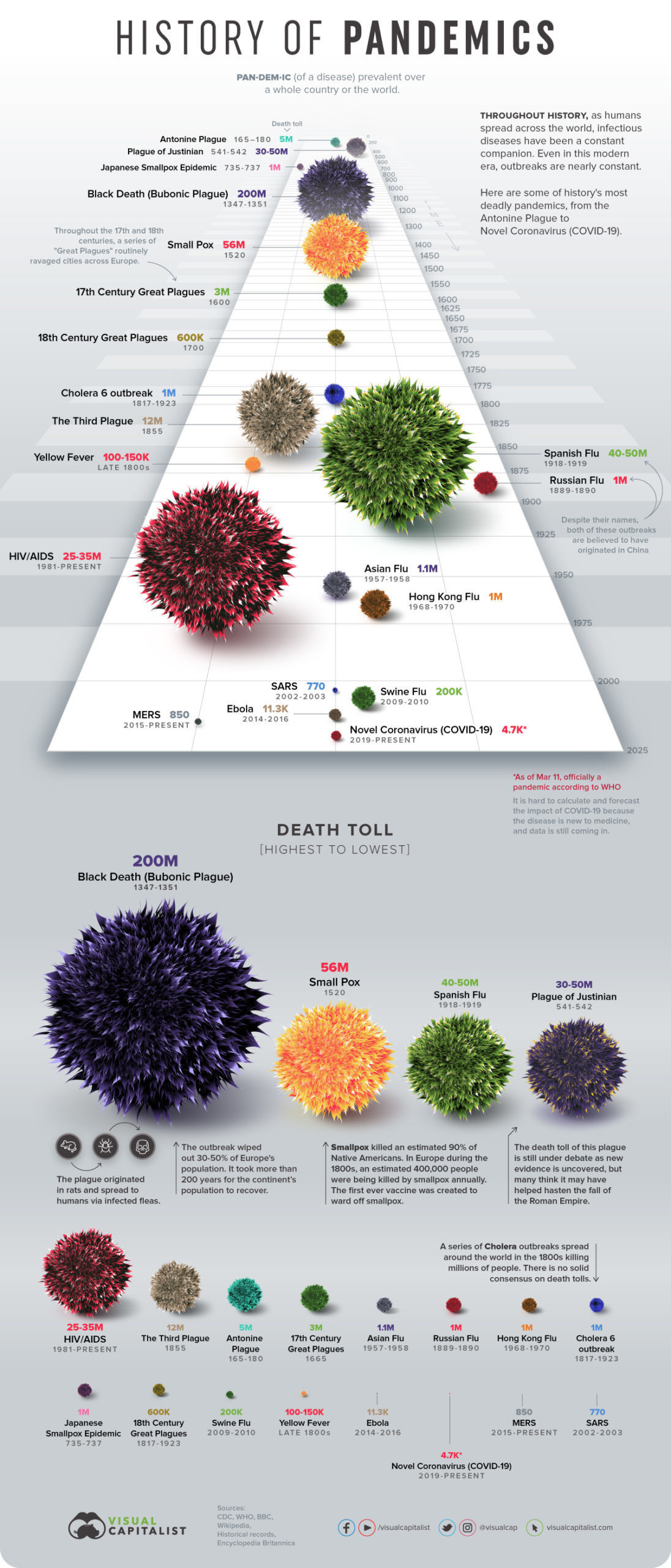
Images of Imperial Modernity: Pandemics, Global Temperature (NYT 29Dec2023), Health & Wealth: “200 years that changed the world” Original Version, New Version, Global Income Distribution, 2008, 2011 (Our World In Data: Inequality Measures), Top 10 countries in Military Spending since 1870, Global Military Spending 2020, Military Spending Countries 2022 (Visual Capitalist). The impoverishment of the Philippines. (NYTimes)
Indo-European Language Tree from the Guardian.
Jenny Cheng’s Chinese Restaurant Site
200 years that changed the world – — THE NEWER ONLINE VERSION
“Tinderbox, Belt & Road: China in the Balkans” Link: https://vimeo.com/802551753 Password: BFNA
The Wall and the Fear: India’s Deadly Border Wall with Bangladesh
“Red is the Blood of the People,” A play by (NYUAD student) Tan Tzy Jiun
First Japanese Buddhist Map of the World Showing Europe, America, and Africa, 1710
Asia’s Circulatory System: Prezi
MMA Heilbrun Timeline of Art History
MMA Heibrun Timeline Essay on Buddhist Art
Port City Workshop Reference Map
Greenwich Village Story Map Model
HISTORY BEYOND — New York Immigrant City
Reading Material for Global Asia Course
SILKROUTES.NET maps page with OBOR
Digital Data Archives Georeferenced historical routes and nodes – Old World
Data Visualization
TRADE ROUTES 11-12th Century FABULOUS EasyZoom Map
Animated Maps
East Asia (Chinese): https://www.youtube.com/watch?v=d-nPRhEapE0&feature=related
East Asia (English): https://www.youtube.com/watch?v=12U3yLR_EeM
Asia state territories, year by year, ancient times to present: https://www.youtube.com/watch?v=c8TNvvjoqvw
GoogleMap: Strategic Sites in Asia’s Circulatory System
Dynamic Graph: Global Flow of People
VISUALIZING CULTURES — MIT/HARVARD JAPAN/CHINA online course